| WHITE LAKE |
|---|
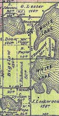
With a surface area of 540 acres, White Lake dominates the eastern halves of Sections 12 and 13 of Highland Township, as well as the western portions of Sections 7 and 18 in adjoining White Lake Township. Of glacial origin, its tranquil shores were a favored camping spot for Native American peoples passing along the old Indian trail to the north (now parts of White Lake and Rose Center Roads). Neither were the early settlers immune to White Lake's charms. As early as 1877 it was reported that "The lake is frequented during the summer by excursion- and picnic-parties, who come to its shores to spend a day in pleasurable pastime, - fishing, rowing, sailing, etc.," Durant, History of Oakland County, Michigan (1877) p. 183. This portion of an 1872 map of Highland Township shows the ownership of the lake's western shores divided between the Lester, Beaumont and Lockwood families.