The
Highland Township Historical Society |
|---|
BACK TO THE HISTORICAL RECORDS PAGE
A Highland Township Gazetteer
An interactive
catalogue of place names within the Charter Township of Highland,
with brief accounts of their origins or significance
Introduction
The following is a list of names which have been used, at various times, to identify the communities, roads, natural features and other places within Highland Township. Where known, the history behind and/or significance of such names is likewise given and many entries include linked cross-references to others of potential interest. The information presented has been gleaned from published histories of the Township; a variety of atlases, plat books and other maps; and the recollections of long-time residents. By their nature, listings of this type are never finished nor complete; however, every effort will be made to correct and add to it over time. Suggested corrections and/or additions may be submitted via email to contact@highlandtownshiphistoricalsociety.com: attention Eugene H. Beach, Jr.
Many of the descriptions employed assume familiarity with Michigan's sectional township system and/or ready access to a map on which the various sections mentioned in such descriptions can be located. A copy of the 1872 Highland Plat Map from F. W. Beers & Co., Atlas of Oakland County, Michigan, is available online courtesy of the Mardos Memorial Library of On-Line Books & Maps . More recent USGS maps of Highland Township are available online courtesy of Maptech, Inc. While somewhat out-of-date, these maps show both natural and man-made features (including homes and buildings) in considerable detail. To use, visit the Maptech, Inc. homepage, then click the "Online Maps" link in the upper right corner. You will then see a link for the Maptech MapServer page. Enter one of Highland's ZIP Codes as a search term (48356 or 48357) will bring up an overall map of the township and surrounding areas. You can then use the centering tool, scroll arrows and zoom controls to move and/or enlarge the view. It is also possible to print copies of these maps in color.
Note that these and all other external links on this page will open in a new browser window.
Contents
POST OFFICES, VILLAGES AND OTHER LOCALES
STREAMS, LAKES AND OTHER WATER
FEATURES
HIGHWAYS, ROADS AND STREETS
THE RAILROAD
INDIAN TRAILS
OTHER NAMED NATURAL AND MAN-MADE
FEATURES
HISTORIC NAMED FARMS
HISTORIC COMMON SCHOOLS
![]()
Post Offices, Villages And Other Locales
CLYDE - The name given to the village and former post office in Section 10. The community was previously known as WHEELER. When the post office was established in the late 1800's, however, there was already a "Wheeler" in Gratiot County, Michigan, so the name was changed to Clyde. It is described in Durant's 1877 History of Oakland County, Michigan, as "...a small village and depot on the Flint and Pere Marquette railway..." The actual platted "Village of Clyde" occupies most of the northeast quarter of the northwest quarter of Section 10, bounded on the east by the CSX railroad, and on the north and west by MILFORD ROAD, although the name is also commonly applied to adjoining areas. The post office at Clyde closed on February 23, 1968, after which its mail has been handled through the HIGHLAND STATION post office.
EAST HIGHLAND - An unofficial designation for the business district and surrounding residential developments in Sections 13 and 24. Centered at the intersection of M-59 (HIGHLAND ROAD) and DUCK LAKE ROAD, "East Highland" is commonly understood to extend from WATERBURY ROAD on the west to the Township border on the east. The name is geographically descriptive and likely evolved by analogy to that of WEST HIGHLAND. It did not come into common use, however, until the mid-20th century, following the construction of M-59 (Highland Road) in 1930's, and the platting of LaSalle Gardens subdivision. The area has never had a separate postal designation; being originally served by the post offices at SPRING MILLS and later HIGHLAND STATION.
HICKORY RIDGE - An unofficial designation for the community centered at the intersection of HICKORY RIDGE ROAD and CLYDE ROAD in Sections 5, 6, 7 and 8. While never a post office, it historically boasted two churches, a school and blacksmith shop. The name is descriptive of both the area's tree cover and elevated position. The name was most often shortened to "THE RIDGE."
HIGHLAND - In the broadest sense, the name given to Township 3 North, Range 7 East, Oakland County, Michigan, pursuant to an act of the Michigan Territorial Legislature dated March 17, 1835. Durant's 1877 History of Oakland County, Michigan, declares that:
The name "Highland" was given to the new township because of its elevated position. Its surface was then supposed to be the highest land in the settled part of Michigan, and is possibly as high as any south of Saginaw. The water runs both north and south within the limits of the township. The Pettibone creek heads in section 10 and runs south; and a branch of Buckhorn creek heads on section 3 and runs north, the heads of these streams not being much more than a mile apart.
The name was also originally given to the village in Section 22 served by the SPRING MILLS POST OFFICE, which was platted under the name "Highland" in 1846.
Beginning in 1903 the post office at HIGHLAND STATION became known simply as HIGHLAND, while that serving the WEST HIGHLAND area was changed from HIGHLAND POST OFFICE to HIGHLAND CORNERS POST OFFICE.
See also: specific entries such as HIGHLAND CENTRE, HIGHLAND CORNERS, HIGHLAND STATION, etc.
HIGHLAND CENTRE - The name initially given to the village in Sections 22 and 27 as platted by Almon Ruggles and Germain St. John in 1872. It is now more commonly known as HIGHLAND STATION or simply HIGHLAND. The name is geographically descriptive of its central location in the Township. Even though the name of the village per se was later changed to Highland "Station," "Centre" continued to be used for many years in other contexts. For example, Durant's 1877 History of Oakland County, Michigan, refers to the cemetery north of the village as "The Highland Centre Burying-Ground." So too, that portion of what is now MILFORD ROAD which runs through Highland Station was called CENTRE STREET well into the 20th century.
HIGHLAND, CHARTER TOWNSHIP OF - The official name of the Township following its adoption of a "charter township" form of government in 1982.
HIGHLAND
CORNERS - A name previously given to the community now called WEST HIGHLAND.
Durant's 1877 History of Oakland County, Michigan, describes it as
consisting of "... a general store, blacksmithy, Baptist church, post-office, and an
assemblage of a few families." The
name is geographically descriptive since the community is centered at the intersection of LIVINGSTON ROAD (now part of M-59) and HICKORY RIDGE ROAD and the lines dividing Sections 19, 20,
29 and 30. While the community itself was called Highland Corners, its official
postal designation was originally HIGHLAND POST OFFICE
or "Highland P.O." This
was itself changed to Highland Corners in 1903, however, to avoid confusion from the
renaming of the HIGHLAND STATION post office to simply HIGHLAND. On April 1, 1906, the name of the post office
was again changed to West Highland, only to close several months later on October 3, 1906.
HIGHLAND, ORIGINAL VILLAGE OF - A name used
to identify the village in Section 22, platted under the name "Highland" in
1846, now better known by its postal designation of SPRING MILLS.
HIGHLAND POST OFFICE - Most commonly abbreviated as "Highland P.O.," this was the official designation of the post office at WEST HIGHLAND until 1903, when it was changed to HIGHLAND CORNERS.
HIGHLAND
STATION; HIGHLAND STATION POST OFFICE - The
name given to the village and post office in Sections 22 and 27, originally called HIGHLAND CENTRE when first platted in 1872. The name was apparently changed from
"Centre" to "Station" in recognition of the growing importance of the
new railroad and depot to the local economy. By the 1890's, however, the community had grown
dissatisfied with the name. In 1898, for
example, a correspondent to the Milford Times wrote:
There has been some talk of changing the name of this beautiful town and in some way get rid of the name "Station" which brands it as a little four-corners. Then, too, there is some confusion in mail between Highland (i.e., the Highland Post Office at West Highland) and Highland Station.
Thus, in 1903, the name of the
local post office was official changed to simply "Highland" while the former
"Highland Post Office" at West Highland was changed to HIGHLAND CORNERS.
HIGHLAND VILLAGE - A name used in Durant's 1877 History of Oakland County, Michigan, and other early references as a synonym for HIGHLAND CENTRE a/k/a HIGHLAND STATION.
HINES CORNERS - The informal name previously given to the intersection of WATERBURY ROAD with what is now M-59, named for the Hines family which once occupied a home on the southeast corner. This area is now known as STUBS CORNERS.
RIDGE, THE - The shortened form of the name given to the community of HICKORY RIDGE.
SEVEN HARBORS - The name given to the subdivision - and by extension to the surrounding community - centered at the intersection of DUCK LAKE ROAD and Beaumont Street in Section 12. It was originally developed in the early 1900's as summer cottages on WHITE LAKE, most of which have been converted to or replaced by year-round homes. The name is descriptive of the various bays, inlets and man-made canals which afford the residents access to the lake.
STUBS CORNERS (also sometimes spelled STUB'S CORNERS) - The informal name given to the intersection of WATERBURY ROAD and M-59, in honor of Ray "Stub" Steele who opened a garage and auto parts store on the northeast corner in the 1940's. This area was previously called HINES CORNERS.
SPRING MILLS; SPRING MILLS POST OFFICE -The name given to the post office in the village in Section 22 which was platted under the name "Highland" in 1846. Since there was already a HIGHLAND POST OFFICE established at WEST HIGHLAND in 1845, the post office established in the so-called ORIGINAL VILLAGE OF HIGHLAND in 1857 was called "Spring Mills P.O." to avoid confusion. The name later came to be used to refer to the community in general, especially after the platting of HIGHLAND STATION in 1872. The name is geographically descriptive; a mill having been built on the waters of PETTIBONE CREEK in 1846.
WEST
HIGHLAND - The name currently given to the community formerly known as HIGHLAND CORNERS . It
is centered at the intersection of M-59 (HIGHLAND ROAD) - formerly LIVINGSTON ROAD - and HICKORY
RIDGE ROAD, at the corner formed by Sections 19, 20, 29 and 30, and is generally
understood to extend as far south on Hickory Ridge Road as the West Highland Cemetery and
West Highland Baptist Church. The former post
office was originally called "Highland P.O.," then "Highland
Corners." From April 1, 1906, until its closure on October 3, 1906, it was
known briefly as "West Highland." The name is geographically
descriptive of the community's location in the western part of the Township.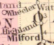
WHEELER - The name originally given to the hamlet later called CLYDE. It honored the area's first settler, Morris Wheeler, in whose home a school was started in the 1840's. The illustration at right is an enlargement of the Highland Township portion of the Railroad Map of Michigan, published by Ormando W. Gray, Philadelphia, in 1873. Notice the name "Wheeler" above that of "Highland" - one of the few maps to use the term. Since there was already a Wheeler, Michigan, in Gratiot County, however, the name of the community was changed to Clyde when the post office was established.
![]()
Streams, Lakes, And Other Water
Features
ALDERMAN LAKE - Straddling the line between Sections 14 and 23, it is one of the chain of intermediate lakes along PETTIBONE CREEK. It was named in honor of Major Alderman, an early Highland settler, who owned land in the vicinity. Durant's 1877 History of Oakland County, Michigan, describes how, in the 1840's, Alderman agreed to allow Major F. Lockwood and Jonas G. Potter to dam Pettibone Creek and flood a portion of his property to power a mill at SPRING MILLS.
ANDRUS LAKE - A name previously given to DUNHAM LAKE.
BASS LAKE - A small lake in the southeast quarter of Section 27, between PICKEREL LAKE and LOWER PETTIBONE LAKE, and flowing into PETTIBONE CREEK.
BUCKHORN CREEK - A creek or stream originating at what was formerly called SPRING LAKE - now KNOBLOCK LAKE - in Section 3, and from there flowing northward into Rose Township where it eventually empties into Buckhorn Lake. It was named by Isaac V. Voorheis, of Waterford Township, who passed through Rose Township in search of land and reportedly found a 20 foot pole laid across the stream on which the Indians had hung a large number of deer antlers.
CHARLICK LAKE - In the
northern portion of Section 9, named for L. J. Charlick who owned surrounding property in
the 1930's.
CURTIS
LAKE - The name formerly given to what is now called LEONARD
LAKE. Durant's 1877 History of
Oakland County, Michigan, includes "Curtis" as one of the Township's five
"most important" lakes identified by name.
It was possibly named in honor of Naham Curtis, who was the first settler to
purchase land in Highland Township in 1832, although his homestead was in Section 36, far
to the south of the lake.
DOWNEY
LAKE - One of the Township's smaller named lakes, located in the southeast quarter
of Section 22 and originally called HASKIN a/k/a HASKINS LAKE. It was renamed for Patrick Downey, b.c. 1802 in
Ireland, who owned the lake and surrounding property in the mid-1870's. While located just west of PETTIBONE CREEK, it has no surface outlet, but is thought to
feed several springs which arise south of it in Section 22.
DUCK
LAKE - One of the Township's larger named lakes, it straddles the line between
Sections 10 and 11, as well as extending northward into Section 2 and southward into
Section 14. Durant's 1877 History of
Oakland County, Michigan, includes it as one of the Township's five "most
important" lakes identified by name. F.
W. Beers & Co., Atlas of Oakland County, Michigan, 1872, indicates that the
northwest portion of current Duck Lake, adjacent to White Lake Road, was once known
separately as GRASS LAKE. Duck
Lake was presumably named for an abundance of waterfowl.
Note that the United States Geological Survey officially recognizes 161 different
lakes with this name in the United States, including thirty in Michigan alone. There is even another "Duck Lake" in
Oakland County, in Oxford Township. See:
the USGS Web Site for more information.
DUNHAM
LAKE - One of the Township's larger named lakes, it straddles the line between
Sections 18 and 19, with a portion extending westward into adjoining Hartland Township,
Livingston County. Durant's 1877 History
of Oakland County, Michigan, includes it as one of the Township's five "most
important" lakes identified by name. It is named for Elijah Dunham who came to
Highland in 1835 and settled on lands in Sections 17 and 18. It was previously
called ANDRUS LAKE in honor of another early settler. A
more detailed History of Dunham Lake can be found on the web site maintained by the Dunham Lake Property Owners Association.
DUNLEAVY LAKE - A small
lake in the northeast quarter of section 15, previously considered to be a southern
extension of UPPER PETTIBONE LAKE. It was named for the Dunleavy family which
developed the adjoining residential subdivision.
FEATHERBED MARSH - A name sometimes applied locally to the marsh or wetland at the north end of Section 26, just west of the intersection of East LIVINGSTON ROAD and BEAUMONT ROAD. Efforts were made twice to fill the northern portion of the marsh so that Livingston Road might follow the section line straight across it. Each time, however, the fill repeatedly sank into the soft, springy bottom for which the marsh is named. As a result the roadway is forced to meander around the northern shoreline. Motorists heading eastbound can still see traces of the filling operation as a band of clear water (i.e., devoid of vegetation) extending out into the marsh at the point where Livingston Road begins curving northward.
GOURD LAKE - Perhaps the smallest named lake in Highland Township, it is located in the northeast corner of Section 9 in the "Highland Hills No. 1" subdivision. It is bounded on the south by Intervale Drive and on the west by Strathcona Street. The name may be reflective of the lake's shape, with its rounded west end tapering into a smaller "neck" to the east. A 1977 Plat Map published by Rockford Map Publishers, Inc., mistakenly gives the name "Gourd L." to TOMAHAWK LAKE; a somewhat larger body of water immediately to the northeast.
GRASS
LAKE - A name applied at various times to two distinctly different bodies of water
within Highland Township. F. W. Beers &
Co., Atlas of Oakland County, Michigan, 1872, designates what is now the far
northwest portion of DUCK LAKE, straddling Sections 3 and 11, as
"Grass Lake." It is presumably this
body of water which Durant's 1877 History of Oakland County intends when it
includes "Grass Lake" as one of the five "most important" lakes within
the Township. By the time the Illustrated
Atlas Of Oakland County, Michigan was published in 1896, however, this original Grass
Lake has disappeared; perhaps because of efforts to drain Duck Lake to reclaim additional
farmland. Instead, the name Grass Lake was
applied to, and continues to be used to identify the lake straddling the line between
Sections 13 and 14, just north of M-59 (HIGHLAND ROAD) and east of WATERBURY ROAD. In
both cases the name is presumably descriptive of the grasses ("marsh hay") such
lakes featured.
HARVEY
LAKE - One of the Township's smaller named lakes, straddling the line between
Sections 15 and 22. It was named for
Harvey Leonard, who received patents for land along both its north and south shores in the
1830's. The possessive form, i.e. "Harvey's Lake" is sometimes seen in
older references while the 1896 Illustrated Atlas of Oakland County, Michigan,
employs the spelling "Harve." Local residents frequently employ a shorter,
monosyllabic version of the name in casual conversation, i.e. "Harv Lake."
HASKIN a/k/a HASKINS LAKE - The name formerly given to DOWNEY LAKE, likely in honor of Harvey W. Haskin, b.c. 1814 in Vermont, who appears on the 1850 Census of Highland Township. Haskin later removed to Sunfield, Eaton County, Michigan, where he appears on the 1870 Census.
HICKORY RIDGE LAKE - In
the west half of Section 17, named for HICKORY RIDGE ROAD
which passes it some distance to the west.
HIGHFIELD LAKE - The name previously given to a small lake in the northwest corner of Section 3, straddling the line between Highland and Rose townships. It lies just north of where Buckhorn Lake Road makes a sharp turn to the west. The name appears on the 1909 USGS map of the "Milford Quadrangle." While the lake itself appears on more recent USGS maps, however, it is no longer named.
HIGHLAND
LAKE - A name applied at various times to two distinctly different bodies of water
within Highland Township. It originally
designated what is now called UPPER PETTIBONE LAKE in
Sections 10 and 15. Currently it is used to
identify the previously unnamed lake/marsh in the northeast quarter of Section 17. MIDDLE ROAD curves around its north shore.
HUFF LAKE - One of the
Township's smaller named lakes, located in the middle of Section 15, just west of LEONARD LAKE. It is
named for Walter Huff, who owned the surrounding property in the 1930's.
KELLOGG LAKE - Straddling the line between the southeast quarter of Section 8 and the southwest quarter of Section 9, it was named for Orson Kellogg who owned the property bordering its eastern shore in the late 1800s/early 1900s.
KELLY'S POND - The name informally given to a shallow, marshy pond in the southeast quarter of Section 21, on the south side of M-59. It was named for the family of J. E. Kelly on whose farm the majority of the pond is located.
KNOBLOCK LAKE - A large lake in the west half of Section
3, incorporating the smaller body of water once known as SPRING
LAKE. It was named for A.F. Knoblock who owned the surrounding property in the
1940's and 50's.
LEONARD
LAKE - Formerly called CURTIS LAKE, it straddles the
line between Sections 14 and 15 and forms one of the chain of intermediate lakes along PETTIBONE CREEK. It
was renamed in honor of the family of Harvey Leonard who settled in Highland in 1835 and
whose descendants owned land surrounding the lake.
MOORE LAKE - In the
southeast quarter of Section 34, and extending southward into Milford Township, it is one
of the chain of intermediate lakes along PETTIBONE CREEK as
it makes its way southward to join the Huron River in the Village of Milford.
MURRAY LAKE - In the
east half of Section 8, named for Sanford L. Murray who purchased adjacent land in 1836.
PENINSULA
LAKE - In Section 10, on the west side of MILFORD ROAD
just south of CLYDE; so named because of the slender peninsula of
land which divides its northern end. Durant's
1877 History of Oakland County, Michigan, includes "Peninsular" Lake as
one of the Township's five "most important" lakes identified by name. It appears, complete with its peninsula and name,
in F. W. Beers' Atlas of Oakland County, Michigan in 1872. Curiously, however, Kace Publishing, 1896
Illustrated Atlas of Oakland County, Michigan, shows a smaller, rounded and unnamed
lake while the 1908 Standard Atlas of Oakland County, Michigan, George A. Ogle
& Co., depicts only an unnamed marsh. The fact a water tower on the nearby CSX railroad drew its water from the lake may account for this
apparent change in its water level. Whatever the reason, however, the lake's
present-day configuration again resembles that depicted on the 1872 map.
PETTIBONE CREEK - A creek or stream, originating at UPPER PETTIBONE LAKE in Sections 10 and 15, and flowing from thence more or less south along a chain of intermediate lakes through Sections 14, 23, 22, 27 and 34 to the Township's southern border. Upon leaving Highland Township it continues its southerly flow through Milford Township and the Village of Milford, where it joins the Huron River. It is named for Levi Pettibone, who settled in what would later become the Village of Milford in 1827.
PETTIBONE
LAKE - The name originally given to what is now called LOWER PETTIBONE LAKE.
PETTIBONE LAKE, LOWER - One of the Township's
larger named lakes, it forms part of the chain of intermediate lakes along PETTIBONE CREEK, straddling the line between Sections 27 and
34. Durant's 1877 History of Oakland
County, Michigan, includes it as one of the Township's five "most important"
lakes identified by name. Originally called
simply PETTIBONE LAKE, the adjective "Lower" was
added in the early 1900's to avoid confusion with the renaming of HIGHLAND
LAKE to UPPER PETTIBONE LAKE. It takes its name from the creek which flows
through it, which was itself named for Levi Pettibone, who settled in what would later
become the Village of Milford in 1827.
PETTIBONE LAKE, UPPER - Originally called HIGHLAND LAKE until at least 1908, it is one of the Township's
larger named lakes. Straddling the line
between Sections 10 and 15, it forms the headwaters of PETTIBONE
CREEK, for which it was renamed in the early 1900's.
Because of its proximity to the railroad, Upper Pettibone
Lake was formerly the site of large commercial ice cutting operations. Each winter large blocks of ice would be sawn from
the frozen lake and stored in a massive ice house for eventual shipment to Detroit by
train. A fire in May, 1929, destroyed both
the ice house and workmen's dormitory. It
takes its name from the creek into which it flows, which was itself named for Levi
Pettibone, who settled in what would later become the Village of Milford in 1827.
PICKEREL
LAKE - One of the smaller named lakes in the Township, it is located in the
northeast quarter of Section 27 and is one of the chain of intermediate lakes along PETTIBONE CREEK. The
name is presumably descriptive of the fish found there.
ROWE LAKE - One of the smaller named lakes in the Township, it is located in the east half of Section 32 and was named for Squire W. Rowe who owned land along its north shore.
SOCIETY LAKES - An early name for an otherwise undefined collection of smaller lakes in the central portion of Highland Township. The earliest known reference to the name is found in John T. Blois, Gazetteer of the State of Michigan In Three Parts, Sydney L. Rood & Co., Detroit (1839), which at page 363 includes the following entry:
Society Lakes, (thus named from their proximity,) are several little lakes, in the vicinity of each other, no one of which exceeds perhaps 50 acres in extent, lying in Highland township, Oakland county, south-west of White lake.
In this sense the name is more properly that of a region or area than one for such lakes themselves, in much the same way "The Ridge" is used to refer to the area in and around HICKORY RIDGE rather than the geographical feature for which it is named.
Since the "Society Lakes" are said to lie
"south-west" of WHITE LAKE, this suggests a location
roughly in the middle of the township. Lakes in this general area include, but are
not limited to GRASS LAKE, WATERBURY
LAKE, LEONARD LAKE, HARVEY LAKE,
DOWNEY LAKE, and PICKERAL LAKE.
The claim that none of the "Society Lakes" exceeds 50 acres in area would
seem to rule out the inclusion of DUCK LAKE within the meaning of
the term. Note, however, that Blois says at page 233 of his Gazetteer that
the "principal" lakes of Oakland County "... are Stony, Thompson's, Square,
Elizabeth, Orchard, Pine, Whitney, Burt, Walled, Silver, White and Society
lakes." The fact "Society Lakes" is deemed a
"principal" lake in the same class as these other major bodies of water seems
odd unless the name embraced at least one sizable lake.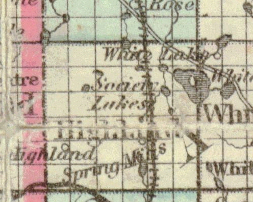
Walter Romig, Michigan Place Names, Wayne State University Press, Detroit (1986), p. 522, cites and essentially repeats Blois' description without further identifying the specific lakes involved. Curiously, however, he adds that the term also embraced and/or referred to "a resort colony southwest of White Lake, dating from 1838." There is absolutely no evidence, however, that any "resort colony" was established in Highland a mere three years after the township's organization! Rather, Romig no doubt confused Blois' description of "Society Lakes" ("south-west of White lake") with the summer resort established on the south and west shores of White Lake itself in the 1890's/early 1900's. See: GROVE POINT SUMMER RESORT.
The name "Society Lakes" is found on the Sectional Map Of Michigan published in 1873 by Chapman & Silas, Chicago; the Highland Township portion of which is shown here. Consistent with Blois' description the name is placed more or less in the middle of the township, roughly southwest of White Lake. While a number of smaller lakes are surrounding this label, the map's lack of detail makes them impossible to identify with certainty.
This 1873 Chapman & Silas map is the last reference thus far found to the "Society Lakes" and the name likely passed out of use once each of its constituant lakes was given its own unique identity. It would be just as easy, and far more precise, to say that one lived on Harvey Lake or Downey Lake than to employ the older, more general name "Society Lakes."
SOUTH LAKE - A
name sometimes given the small pond in the southwest quarter of Section 30, near the east
end of Spencer Lee Drive. It is named as such on the 1977 Plat Map published by
Rockford Map Publishers, Inc.
SPRING
LAKE - The name formerly given to a small lake in the southeast quarter of Section
3 which forms the headwaters of BUCKHORN CREEK. It is identified by name in both Kace
Publishing Co., 1896 Illustrated Atlas of Oakland County, Michigan, and George A.
Ogle & Co., 1908 Standard Atlas of Oakland County, Michigan. It was
subsequently enlarged and renamed KNOBLOCK LAKE in honor of
A.F. Knoblock, who owned the surrounding property..
TAGGETT LAKE - In the west half of Section 9, named for Abram C. Taggett who purchased land adjoining the lake in 1836. Because of its shallow depth this lake will partially dry in a hot summer. It is likely for such reasons it is called "Taggett Marsh" in both Kace Publishing Co., 1896 Illustrated Atlas of Oakland County, Michigan, and George A. Ogle & Co., 1908 Standard Atlas of Oakland County, Michigan.
TOMAHAWK LAKE - A small lake in the northeast corner of Section 9, just south of the intersection of CLYDE ROAD and BUCKHORN LAKE ROAD. A 1977 Plat Map published by Rockford Map Publishers, Inc., mistakenly calls it GOURD LAKE, confusing it with the smaller lake by that name located immediately southwest.
VINEGAR MILL POND - A
man-made pond or small lake formed by the damming of PETTIBONE
CREEK in the old village of SPRING MILLS, just north of
East LIVINGSTON ROAD. It is named for the cider and
vinegar mill built c. 1846 to which the mill pond supplied power. Now located within
the Highland State Recreation Area, the current dam was built by the Michigan Department
of Natural Resources.
WATERBURY
LAKE - One of the smaller named lakes in the Township, it is located largely in
southeast quarter of Section 23 and is named for the family of Archibald Waterbury who
owned land surrounding the lake.
WHITE
LAKE - The largest body of water in Highland Township, even though partially
located in adjoining White Lake Township to the east, it occupies the majority of the east
halves of Sections 12 and 13. Durant's 1877 History
of Oakland County, Michigan, p. 183, claims the name of White Lake Township was
"derived from the beautiful sheet of water which lies partly within its limits"
and describes how the lake itself was a favorite Indian camping ground.
WOODRUFF LAKE - In the southeast quarter of Section 9. The name is possibly a corruption of that of Norman Woodworth, who owned land along the south shore of the lake in the 1870's.
![]()
Introduction
Highland's historic roads and streets may be grouped into three broad categories, i.e. (i) irregular roadways whose meandering course suggests they might follow preexisting Indian trails or footpaths (e.g., BEAUMONT ROAD, REID ROAD and portions of MILFORD ROAD); (ii) so-called "Section Line Roads" which more or less follow the boundaries between section lines; and (iii) planned streets within the historic platted villages of SPRING MILLS, HIGHLAND CENTRE (HIGHLAND STATION) and CLYDE. Note that, because of its numerous lakes, Highland's section line road system is far less developed than that of a typical Michigan township. For example, ROWE ROAD's eastern progress stops at Milford Road due to the presence of LOWER PETTIBONE LAKE , while UPPER PETTIBONE LAKE poses a similar obstacle to the eastern extension of MIDDLE ROAD. This has resulted, in some cases, to the placement of roadways along internal, fractional section lines, e.g., DUCK LAKE ROAD, which follows quarter section lines through the middle of Sections 36, 25, 24, 13 and 12. Even true section line roads such as Middle Road, LIVINGSTON ROAD and HARVEY LAKE ROAD, however, must occasionally divert from their normally straight path to avoid intervening lakes or marshes.
The names given such historic roadways tend to fall into two broad groupings. The first is composed of names which are "geographically descriptive," either because they denote the road's origin or destination (e.g., Milford Road, Livingston Road, CLYDE ROAD, etc.) or else reference some nearby natural feature (e.g., DUCK LAKE ROAD, PETTIBONE LAKE ROAD, etc.). The second grouping consists of names which honor those who, at one time or another, owned land along the road's route (e.g., Beaumont Road, WARDLOW ROAD, WATERBURY ROAD, etc.). Note that names of roads in this second category might sometimes change, as one family moved away and/or another became more prominent. It further appears a single road might have two or more names simultaneously, depending upon which family the speaker was more familiar with. It was only in the mid-1900's that the Road Commission for Oakland County adopted the permanent, "official" names by which such roads are known today.
* * * * *
BEAUMONT ROAD - A meandering north-south road in the southeast part of the Township, named for members of the Beaumont family who owned land at its northern end. The road begins at its intersection with Cooley Lake Road along the Township's southern border, then proceeds north through the middle of Sections 35 and 26 until its intersection with East LIVINGSTON ROAD. Its irregular course through the rolling terrain suggests it may be a remnant of the WALLED LAKE TRAIL which is known to have passed through Section 35. It should not be confused with Beaumont Street in Section 12.
BENTLER ROAD, THE - A name formerly given to REID ROAD in honor of Jacob "Jake" Bentler who owned land in the northeast quarter of Section 34 through which it passed. The Milford Times for Feb. 8, 1929, refers to "the Bentler road a half mile south" of LONE TREE ROAD. Bentler was from Germany and for a time ran a brewery on his property. The Milford Times for April 24, 1880, describes a brawl which broke out at his establishment and notes that "the Pettibone Brewery is one of the worst localities in this vicinity, and savage fights are not at all uncommon there." It was also formerly known as THE BREWERY ROAD and the spot where it formerly crossed the CSX RAILROAD was commonly called THE BREWERY CROSSING.
BISHOP STREET - An east-west street in CLYDE, named for Julian Bishop, the county surveyor who surveyed the village on behalf of Lyman Johnson.
BREWERY ROAD, THE - Another name once given to THE BENTLER ROAD, now REID ROAD. It derives from the fact Jacob "Jake" Bentler, who owned land along the road, once ran a brewery on his property.
BRUSH STREET - A name formerly given the western segment of WARDLOW ROAD between MILFORD ROAD and HICKORY RIDGE ROAD. It apparently referred to the dense vegetation which lined the road. Even today (2003), this part of Wardlow Road is noted for its canopy of mature trees, which have earned it formal recognition as a "Natural Beauty Road."
BUCKHORN LAKE ROAD - A north-south section line road running between Sections 3 and 4 from CLYDE ROAD to the Township's northern border. The earliest maps show it straight throughout its entire length, but the 1908 Standard Atlas of Oakland County, Michigan, and subsequent maps depict the current westward "jog" at its north end, to bypass the small lake on the Highland-Rose Township line. It is named for Buckhorn Lake in Rose Township, by which a portion of it passes further north. The name "Buckhorn" finds frequent use in Rose Township as the name of a lake, creek, road and former tavern. It was originally bestowed on the creek by Isaac V. Voorheis, of Waterford Township, who passed through Rose Township in search of land. He reportedly found a 20 foot pole laid across the stream on which the Indians had hung a large number of deer antlers.
CENTRE STREET - The name formerly given to that part of MILFORD ROAD which passes through the platted village of HIGHLAND CENTRE, (HIGHLAND STATION.) The name is geographically descriptive of the road's central location through the village and is usually seen with the English ("re") spelling. It was chosen by Almon Ruggles and Germain St. John who platted the village in 1872. Many long-time residents and businesses continued to use the name well into the mid-1900's.
CLARK STREET - A north-south street in HIGHLAND STATION, west of and parallel to KING STREET. It was initially laid out in 1882 by John Bernard and Betsey (Westfall) Crouse as part of the plat of Crouse's Subdivision. Originally the street was only 264 feet in length, starting at West LIVINGSTON ROAD on the north and terminating in front of Lot 46 at McPHERSON STREET on the south. When the former John Robert Crouse property to the south was later platted as "Evergreen Annex" and""St. John's Annex," however, Clark Street was extended south through Lot 46 of the original Crouse's Subdivision plat to its current intersection with George Street. Its name honors E. A. and Lockwood Clark, who settled in Highland c. 1834-35.
CLYDE ROAD - A major east-west section line road through the northern portion of the Township. It is named for the village of CLYDE where it begins at its intersection with MILFORD ROAD. It then proceeds due west along the line dividing Sections 3 and 10, 4 and 9, 5 and 8, and 6 and 7, passing through the community of HICKORY RIDGE on its way to the Township's western border.
COMMERCE STREET - A name given on some early maps to that portion of SPRING MILLS ROAD lying within the ORIGINAL VILLAGE OF HIGHLAND (SPRING MILLS.) The name is thought to refer to "commerce" or "business" generally, rather than to any connection with Commerce Township several miles to the east.
CRAPO STREET - An east-west street within the original 1872 Ruggles and St. John plat of HIGHLAND CENTRE (HIGHLAND STATION), running between MILFORD ROAD and ST. JOHN STREET. Only 264 feet in total length, Crapo Street is arguably the shortest historic roadway in the Township. The name is properly pronounced with a long "a" sound (i.e., Cray'poe) and honors Henry Howland Crapo (1804-1869); a successful lumberman, businessman and governor of Michigan from 1866 to 1869. Of special relevance to Highland, however, was Crapo's role as president of the Flint and Holly Railroad, predecessor to the Flint & Pere Marquette Railway. See the entry for The Railroad below. In 2003 residents of the street petitioned to have the name changed, claiming "embarrassment" over its frequent mispronunciation. As a compromise, the word "Governor" was added to clarify the fact the street honors Henry Howland Crapo.
DUCK LAKE ROAD - A major north-south road in the eastern portion of the Township. It begins at its intersection with Cooley Lake Road at the Township's southern border, then proceeds northward through the middle of Sections 36, 25, 24, 13 and 12, before eventually becoming an unpaved "two-track" which terminates at WHITE LAKE ROAD. The official status of this final segment has long been in doubt. As of late 2002, however, the Road Commission for Oakland County is studying the improvement of this portion as part of planned improvements to the WHITE LAKE ROAD/ROSE CENTER ROAD intersection. Although this roadway literally skirts the western shore of WHITE LAKE, it is nevertheless named for DUCK LAKE located approximately a quarter mile to its west; perhaps because there was already a WHITE LAKE ROAD in Section 1.
ELEANOR STREET - A north-south street in Section 22, running between East LIVINGSTON ROAD and M-59 (HIGHLAND ROAD), just east of and parallel to the CSX railroad. The origin of the name is uncertain.
ELIZABETH LAKE ROAD - Prior to the construction of M-59 (HIGHLAND ROAD), the principal route from Highland to the county seat of Pontiac was via Elizabeth Lake Road. From "downtown" HIGHLAND STATION a motorist would proceed east on GRUBB ROAD (now East LIVINGSTON ROAD) to WATERBURY ROAD, then proceed north to what was then considered the western terminus of Elizabeth Lake Road. Here one turned right and headed east (along the current route of M-59), past GEES "Cement Block Store" and on into White Lake Township. When M-59 was constructed in the late 1930's, it followed the route of Elizabeth Lake Road from the township line to Waterbury Road, then continued on in a broad curve to the southwest, passing to the south of ALDERMAN LAKE before joining the west portion of SPRING MILL ROAD. As a result, the current western terminus of Elizabeth Lake Road is in White Lake township adjacent to the K-Mart store.
GOVERNOR CRAPO STREET - See CRAPO STREET.
GRUBB ROAD - The name formerly given to that part of what is now called East LIVINGSTON ROAD, from east of the CSX railroad to its terminus at DUCK LAKE ROAD. It was apparently named for a family whom long-time residents recall living along the east end of the road. The name was changed in the 1960's at the request of residents who disliked the connotations suggested by the name "Grubb."
HARVEY LAKE ROAD - A north-south section line road in the northeast portion of the Township, named for HARVEY LAKE which is passes on the east. As presently constituted it begins at East LIVINGSTON ROAD in the southeast quarter of Section 22 and heads northeast, across M-59 (HIGHLAND ROAD), until reaching the line dividing Sections 22 and 23. Here it turns due north, meandering around the east side of LEONARD LAKE, until reaching the intersection of MILFORD ROAD and WHITE LAKE ROAD at the corner of Sections 2, 3, 10 and 11. The portion in the southeast quarter of Section 22, within the ORIGINAL VILLAGE OF HIGHLAND (SPRING MILLS), was formerly called MAIN STREET. Likewise, the portion north of M-59 was formerly sometimes known as THE MAUGH ROAD in honor of John Maugh, who owned the historic grist mill on the east side of the road from 1907 to 1943.
HICKORY RIDGE ROAD - A section line road and major north-south thoroughfare in the western third of the Township, named for the community of HICKORY RIDGE through which it passes. It enters from the south along the line between Sections 31 and 32 and proceeds due north to the Township's northern border, with only a slight curve around the hill in the southwest quarter of Section 6.
HIGHLAND ROAD - See M-59 (HIGHLAND ROAD).
HUFF ROAD, THE - A name sometimes given informally to that part of present-day WARDLOW ROAD between MILFORD ROAD and HICKORY RIDGE ROAD; so called in honor of brothers Richard and Eno Huff, who owned property on both sides of the road in Sections 16 and 21.
JOHN STREET - A north-south street in HIGHLAND STATION, west of and parallel to CENTRE STREET (now MILFORD ROAD). It was initially laid out in 1882 by John Bernard and Betsey (Westfall) Crouse as part of the plat of Crouse's Subdivision. Originally the street was only 264 feet in length, starting at McPHERSON STREET on the south and ending at West LIVINGSTON ROAD on the north. When the Waterbury and St. John properties to the north of Livingston Road were laid out into lots under "Supervisor's Plat No. 4,"however, John Street was extended northward to its present intersection with M-59 (HIGHLAND ROAD). Local folklore sometimes claims this roadway was supposed to honor the St. John family, but that the street sign painter mistook the "St." in the name St. John as an abbreviation for "Street" and so named it simply John Street; forcing the supposedly later naming of a second street ST. JOHN STREET. In fact, St. John Street was in existence and named some ten years before John Street was first laid out. Rather, it appears the name John Street was chosen to honor both John Bernard Crouse - who platted it - and his son, John Robert Crouse, who owned property to the south. Regardless, those not familiar with the community sometimes confuse this roadway with the similarly named St. John Street.
JOHNSON STREET - A north-south street in CLYDE, named in honor of Lyman Johnson, who platted the village in 1875.
KING STREET - A north-south street in HIGHLAND STATION, west of and parallel to JOHN STREET. It was initially laid out in 1882 by John Bernard and Betsey (Westfall) Crouse as part of the plat of Crouse's Subdivision. Originally the street was only 264 feet in length, starting at West LIVINGSTON ROAD on the north and terminating in front of Lot 41 at McPHERSON STREET on the south. When the former John Robert Crouse property to the south was later platted as "Evergreen Annex" and"Hayden's Highland Homes,"however, King Street was extended south through Lot 41 of the original Crouse's Subdivision plat to its current intersection with George Street. Its name honors Thomas F. King, who worked for John Bernard Crouse as sales manager of the Highland Pickle Works.
LIVINGSTON ROAD, EAST and WEST - A section line road and formerly the main east-west road in the southern part of the Township. The road's name is geographically descriptive of its being a major route from Highland to Livingston County. At present it begins on the east at DUCK LAKE ROAD and runs west along the section line between Sections 24 and 25, 23 and 26, and 22 and 27 to its intersection with MILFORD ROAD. This easterly portion was originally named GRUBB ROAD, but is now called East Livingston Road. In turn, West Livingston Road begins at the intersection of Milford Road and proceeds west along the section line between Sections 21 and 28. The road originally continued further west through WEST HIGHLAND to the Livingston County line, but this portion was replaced in the 1930's by the construction of M-59 (HIGHLAND ROAD). That part of Livingston Road within the platted village of HIGHLAND CENTRE (HIGHLAND STATION) is sometimes shown on old maps as Livingston "Street." Early maps show that what is now East Livingston Road once extended further east, across Duke Lake Road, into White Lake Township, where it eventually intersected Ford Road. There was also a secondary road which turned south along the east line of Section 25 until it joined TEEPLE LAKE ROAD. Both of these roadways were abandoned in the late 1940's, however, after the lands on the east side of Duck Lake Road were incorporated into Highland Recreation Area.
LOCKWOOD ROAD, THE - A name formerly given to PETTIBONE LAKE ROAD, likely in honor of L. D. Lockwood who owned land in Section 35 through which the road once passed. The Milford Times for Feb. 8, 1929, refers to "the Lockwood road on the east side of Pettibone."
LONE TREE ROAD - A section line road in the southwest portion of the Township. It begins at MILFORD ROAD and proceeds west along the line dividing Sections 27 and 34, 28 and 33, 29 and 32, and 30 and 31, until reaching the Township's western border. It is named for a massive 250 year-old white oak tree which once stood on the southwest corner of its intersection with Milford Road. The tree was removed in September, 1986, as a purported hazard to traffic along Milford Road. It was formerly called PEACOCK AVENUE.
M-59 (HIGHLAND ROAD) - the only Michigan State Highway (formerly called "Michigan State Trunk Line"), as well as the major east-west thoroughfare in Highland Township. It begins at the eastern Township border and proceeds due west along the line between Sections 13 and 24 (formerly the western portion of ELIZABETH LAKE ROAD) to its intersection with WATERBURY ROAD, then sweeps southwest in a gentle curve through Section 23 until just west of its intersection with HARVEY LAKE ROAD. Here it begins to follow the route of former SPRING MILLS ROAD through Section 22, under the CSX Railroad tracks, to its intersection with MILFORD ROAD. Continuing westward, the Highway again curves gently southwest until it intersects West LIVINGSTON ROAD at the corner of Sections 20, 21, 28 and 29. It thereafter proceeds due west, along the former route of Livingston Road, on the line between Sections 20 and 29, and 19 and 30, to the Township's western border. Originally constructed in the late 1930's as a two-lane paved road, M-59 underwent major expansion in the early 1980's into a four-lane divided boulevard. Unlike Federal Interstate and U.S. Highways, the numbering of Michigan's State Highways/Trunk Lines does not follow any rule or pattern. For an interesting history of all Michigan State Highways - including M-59 - visit the Michigan Highways Web Site maintained by Christopher J Bessert. For the history of M-59 in particular, click this link. In addition to its official numeric designation as a State Highway, M-59 is also known as "Highland Road" throughout its length from Waterford Township on the east to Howell, Livingston County, Michigan, on the west. See also: the entries for THE BLINKER and THE VIADUCT.
MAIN STREET - This name was formerly applied to two distinctly different roads within the Township. The 1872 Atlas of Oakland County, Michigan, F. W. Beers & Co., shows that it was initially given to that portion of present-day HARVEY LAKE ROAD which passed through the ORIGINAL VILLAGE OF HIGHLAND (SPRING MILLS). Likewise, the 1908 Standard Atlas of Oakland County, Michigan, George A. Ogle & Co., shows that it was also used as the name for that part of MILFORD ROAD which runs east-west through the platted village of CLYDE, between CLYDE ROAD and the CSX railroad. Some long-time residents of Clyde still refer to this section as "Main Street."
MAUGH ROAD, THE - A name previously given informally to that part of present-day North HARVEY LAKE ROAD north of its intersection with M-59 (HIGHLAND ROAD). It honors John Maugh, who owned and operated the historic Lockwood grist mill on the east side of the road from 1907 to 1943.
McPHERSON STREET - An east-west street in HIGHLAND STATION, south of and parallel to West LIVINGSTON ROAD, it begins on the east at CENTRE STREET (now MILFORD ROAD) and terminates on the west 264 feet past its intersection with CLARK STREET. It was initially laid out in 1882 by John Bernard and Betsey (Westfall) Crouse as part of the plat of Crouse's Subdivision and was named for Peter McPherson, an immigrant from Scotland who settled on the west side of LOWER PETTIBONE LAKE in 1834.
MERIBAH STREET - An east-west street in CLYDE between MILFORD ROAD and RAILROAD STREET. The name is Hebraic, meaning "quarrel" or "strife," and was given by Moses to the fountain in the wilderness of Sin/Zin, near Rephidim, which issued from the rock in Horeb that he smote by divine command, See: Exodus 17: 1-7. The same fountain is likely that which finds mention by name in Numbers 27: 14. The reasons for conferring the name on the street are unclear.
MIDDLE ROAD - An east-west section line road through the northwest portion of the Township. It begins at its intersection with MILFORD ROAD and proceeds due west along the line dividing Sections 9 and 16, 8 and 17, and 7 and 18 to its intersection with TIPSICO LAKE ROAD at the Township's western border. The name is geographically descriptive of its relative position between CLYDE ROAD and WARDLOW ROAD; the two other east-west roads in the northwest part of the Township. It was formerly known as WATER STREET.
MILFORD ROAD - A county road and the major north-south thoroughfare through the central part of Highland Township. It begins at the Township's southern border and proceeds north-northwest through the west half of Section 34, before turning more or less due north as it continues through Sections 27, 22, 15 and 10, where it intersects CLYDE ROAD in the village of CLYDE . Here it turns east, roughly following the line between Sections 3 and 10 to its intersection with Harvey Lake and White Lake Roads, at the corner of Sections 2, 3, 10 and 11. Here it again turns north, following the line between Sections 2 and 3 to the Township's northern border. The road is the principal route south toward the Township and Village of Milford, for which it is named. The portion of Milford Road passing through HIGHLAND CENTRE (HIGHLAND STATION) was formerly known as CENTRE STREET well into the mid-1900's. So too, early maps identify parts of Milford Road passing through the platted village of Clyde as OAKLAND STREET and MAIN STREET. Curiously, the portion of Milford Road between the Village of Milford and the Highland Township line was formerly called "Highland Street." A short segment of this still remains, just west of the Prospect Hill shopping center, between Milford and Commerce Roads. In the early part of the 20th century Milford Road formed a part of the NEW HUDSON-HOLLY AUTO TRAIL.
NEW HUDSON-HOLLY AUTO
TRAIL - Among the countless difficulties faced by early motorists was the
problem of finding and following the best route to one's destination. Road maps were
nonexistent and would have proved useless in any event, since dirt roads built for local
horse and buggy traffic often lacked names and/or street signs. To remedy this
problem, various auto clubs, oil and tire companies and civic groups began to establish
"auto trails"by marking the routes between major cities and towns with signs
bearing brightly colored bands and/or distinctive logos. Several such routes
achieved lasting fame, such as the Lincoln Highway (now US-30), running from New York City
to San Francisco, and the Dixie Highway (now I-75), running from Michigan
to Florida. There were also, however, numerous lesser known auto trails, including
over 20 in Michigan alone. Among these was the New Hudson-Holly Auto Trail -
essentially current MILFORD ROAD - which connected Grand River
Road in New Hudson with the Dixie Highway's Fenton-Holly cutoff. A 1921 Rand
McNallyAuto Trails map shows this route was marked with signs bearing orange-white-orange
bands like that shown here. These signs would have been fixed to or painted on
telephone poles, trees or simple wooden posts at or near intersections so that the early
motorist would know which way to turn.
from Michigan
to Florida. There were also, however, numerous lesser known auto trails, including
over 20 in Michigan alone. Among these was the New Hudson-Holly Auto Trail -
essentially current MILFORD ROAD - which connected Grand River
Road in New Hudson with the Dixie Highway's Fenton-Holly cutoff. A 1921 Rand
McNallyAuto Trails map shows this route was marked with signs bearing orange-white-orange
bands like that shown here. These signs would have been fixed to or painted on
telephone poles, trees or simple wooden posts at or near intersections so that the early
motorist would know which way to turn.
Faced with the proliferation of privately marked trails, Michigan adopted an official highway numbering system in 1918. The federal government followed suit a few years later with the creation of the U.S. Highway system in 1926. As a result, theold auto trails with their colorful signs quickly faded into history, although a few - such as the Dixie Highway - live on as "official" street names. For more on the history of Michigan's early auto trails visit the "Historic Auto Trails" pages at the Christopher J. Bessert's Michigan Highways website.
NORTHWESTERN HIGHWAY - Current Highland residents know Northwestern Highway (M-10) as the boulevard which runs diagonally in a northwest direction (hence the name) from the Lodge Freeway/I-696 interchange in Southfield to Orchard Lake Road in Farmington Hills, where it abruptly ends. For several decades, however, Michigan highway plans called for the extention of Northwestern Highway across all of western Oakland County until it eventually joined US-23 just south of Flint. Plat maps from 1947 and 1956 show that this proposed extension would have passed through Highland, entering the township in Section 36, just south of Teeple Lake Road. From here it would have proceeded northwest through Sections 25, 24, 23, 14, 10 and 4. Its path would have crossed DUCK LAKE ROAD south of East LIVINGSTON ROAD; intesected M-59 just west of WATERBURY ROAD; skirted the north shores of ALDERMAN, LEONARD and UPPER PETTIBONE lakes; crossed MILFORD ROAD just south of CLYDE; and exited the township where Fish Lake Road crosses into Rose Township. While this proposed extension of Northwestern Highway was never constructed, proposals for some sort of major highway through western Oakland County continued (and continue) to circulate. For example, I-275 was originally proposed to continue north from Novi to intersect I-75 near Holly - a plan at least partially fulfilled with the recent construction of M-5 from I-275 to Pontiac Trail.
OAKLAND STREET - The 1908 Standard Atlas of Oakland County, Michigan, George A. Ogle & Co., p. 53, includes a map of the platted village of CLYDE which identified that part of MILFORD ROAD between SHERMAN ROAD and CLYDE ROAD as "Oakland"Street.
PEACOCK AVENUE - A former name for LONE TREE ROAD. There are several different theories as to the origin of the name. Some claim it honored the wife of Bud Thornton, a resident along the road, whose maiden name was Peacock. Others suggest it came from the fact one or more farmers in the area raised peacocks, whose feathers were fashionable in the late 1800's/early 1900's. Still others suggest the name was a sarcastic reference to the wealth and/or social status (real or imagined) of certain residents along the road.
PETTIBONE LAKE ROAD - A north-south road in the southeast portion of the Township. It begins at the Township's southern border near the southwest corner of Section 35 and proceeds north, eventually following the line between Sections 34 and 35, and 26 and 27, until it terminates at East LIVINGSTON ROAD. It is named for LOWER PETTIBONE LAKE, which is passes on the east. It was formerly called THE LOCKWOOD ROAD.
RAILROAD STREET - The eastern most street in the platted village of CLYDE, running north-northeast on the west side of and parallel to the CSX tracks. The name is descriptive of its location beside and provision of access to the railroad.
REID ROAD - A meandering east-west road in the eastern two-thirds of Section 34, running between MILFORD ROAD and PETTIBONE LAKE ROAD. It was named for the family of brothers Hub and Frank Reid, who owned land in the area. It once ran straight through across the CSX railroad tracks, but a tragic accident in the late 1990's prompted closure of the grade crossing. It was formerly called THE BENTLER ROAD and THE BREWERY ROAD, while the grade crossing itself was known as THE BREWERY CROSSING. Its irregular course suggests it may be a short remnant of the old SHIAWASSEE TRAIL.
ROSE CENTER ROAD - A road in Section 1 in the northeast corner of the township, running diagonally from the southeast to the northwest. It was originally considered part of and named WHITE LAKE ROAD, which in turn followed the route of an old Indian trail which passed north of WHITE LAKE on its way from Pontiac to Shiawassee County (See below). This diagonal portion was later renamed Rose Center Road to reflect its destination in Rose Township. In turn, the name WHITE LAKE ROAD was given to the roadway that runs west-south-west across Sections 1 and 2 before intersecting MILFORD ROAD and HARVEY LAKE ROAD. As a result, the name WHITE LAKE ROAD is now applied to two discontinuous roadways, i.e. (i) the east portion between Clarkston and Highland, and (ii) the west portion between Tipsico Lake Road and Tyrone Township.
ROWE ROAD - A "semi-sectional" line road in Sections 33 and 34, named for Squire W. Rowe; a prominent early settler who owned land in the vicinity. It begins at MILFORD ROAD and proceeds due west along the Township's southern border until reaching the line dividing the east and west halves of the southwest quarter of Section 33. Here it turns due north, running along this quarter section line until it reaches LONE TREE ROAD.
RUGGLES ROAD - The name given on older maps to a road - long since abandoned - in the southwest quarter of Section 22 at the south end of the plat for the ORIGINAL VILLAGE OF HIGHLAND (SPRING MILLS). It appears to have begun on the west where GRUBB ROAD (now East LIVINGSTON ROAD) crosses the line dividing the east and west halves of the southeast quarter of Section 22, then proceeded roughly northeast to its intersection with MAIN STREET (now South HARVEY LAKE ROAD). Here it turned roughly southeast, over the dam on PETTIBONE CREEK and past the nearby cider mill to rejoin Grubb Road just west of the line dividing Sections 22 and 23. The 1872 Atlas of Oakland County, Michigan, F. W. Beers & Co., includes a plat for "Highland: Spring Mills P.O." which depicts this road by name and it can likewise be seen in same publication's map of the Township as a whole. It is also shown on the map of Highland Township found in Kace Publishing Co., 1896 Illustrated Atlas of Oakland County, Michigan. By the time of publication of the 1908 Standard Atlas of Oakland County, Michigan, George A. Ogle & Co., however, this roadway has disappeared and Main Street (now South Harvey Lake Road) is shown continuing further south all the way to Grubb Road (now East Livingston Road). The closure and dismantlement of the cider mill c. 1903 no doubt eliminated the need for a separate roadway to service it. This road was named for the Ruggles family which owned land to the west. It should not be confused with RUGGLES STREET in HIGHLAND STATION.
RUGGLES STREET - An east-west street within the original 1872 Ruggles and St. John plat of HIGHLAND CENTRE (HIGHLAND STATION). As originally laid out it began at CENTRE STREET (now MILFORD ROAD) and proceeded due east, across ST. JOHN STREET to the CSX railroad. It does not appear, however, that the east-most segment (between lots 89 and 91 of the original plat) was ever constructed. When the Waterbury and St. John properties west of Milford Road were laid out into lots under "Supervisor's Plat No. 4," Ruggles Street was extended one block west of Milford Road so as to intersect North JOHN STREET. The street was named for Almon Ruggles who, with Germain St. John, platted Highland Station in 1872. It should not be confused with the former RUGGLES ROAD in the ORIGINAL VILLAGE OF HIGHLAND (SPRING MILLS).
SHERMAN STREET - An east-west street in CLYDE. It was likely named in honor of Union Gen. William Tecumseh Sherman, a popular hero of the Civil War, whose memoirs were published in 1875, the same year Clyde was platted.
SOUTH STREET - The original 1872 Ruggles and St. John plat of HIGHLAND CENTRE (HIGHLAND STATION) included an east-west street named "South Street" at the southern-most end of the village. It is shown as commencing at CENTRE STREET (now MILFORD ROAD) approximately 480 feet south of LIVINGSTON ROAD, and running due east all the way to the CSX railroad, intersecting ST. JOHN STREET midway along its length. For reasons still not clear this street was apparently never constructed and no right-of-way is shown for it in the current plat books.
SPRING MILLS ROAD - A former east-west roadway in Section 22 in the ORIGINAL VILLAGE OF HIGHLAND (SPRING MILLS.) It began at its intersection with current South HARVEY LAKE ROAD and ran west-northwest to the south shore of DOWNEY LAKE, then turned to head due west to its termination at MILFORD ROAD, on the north side of HIGHLAND CENTRE (HIGHLAND STATION). The portion within the platted village at Spring Mills is shown on some early maps as COMMERCE STREET while the portion within Highland Centre/Highland Station is sometimes called Spring Mills "Street." When M-59 (HIGHLAND ROAD) was first constructed in the late 1930's it was built over that part of Spring Mills Road from Downey Lake to Milford Road, leaving only a short segment of the original road to the east. This residual portion was later shortened even further, when its intersection with M-59 was closed as part of the highway's widening in the early 1980's.
ST. JOHN STREET - A north-south street within the original 1872 Ruggles and St. John plat of HIGHLAND CENTRE (HIGHLAND STATION), located east of MILFORD ROAD and west of the CSX railroad. As originally laid out it began on the north at its intersection with SPRING MILLS ROAD (later M-59 a/k/a HIGHLAND ROAD) and proceeded due south, across east LIVINGSTON ROAD, to its planned intersection with SOUTH STREET. Since South Street was apparently never constructed, however, St. John Street has historically dead-ended approximately 480 feet south of Livingston Road. Moreover, its intersection with M-59 on the north was closed off and abandoned when that highway was widened in the early 1980's. The street was named for Germain St. John who, with Almon Ruggles, platted Highland Station in 1872. Some older records employ the possessive form of the name, i.e. "St. John's" or "St. Johns" Street. Those not familiar with the community sometimes confuse this roadway with the similarly named JOHN STREET.
TEEPLE LAKE ROAD - An east-west road in Section 25. It begins at DUCK LAKE ROAD, just over one-half mile south of east LIVINGSTON ROAD, then proceeds east into Section 31 of White Lake Township. Here it turns south to join Ford Road. Its name denotes the fact it meanders around the southwest portion of Teeple Lake. In turn, both Teeple Lake and nearby Teeple Hill are likely named in honor of Jacob Teeples (with a final "s"); an early settler on Section 31 of White Lake Township. Note, however, that the 1908 Standard Atlas of Oakland County, Michigan, George A. Ogle & Co., shows the name of the summit as "Steeple Hill" and that of the lake as "Steeple Hill Lake." Was this an error on the publisher's part, or was this indeed the original name for the hill and associated lake? Suffice it to say an "s" was dropped at some point, either at the beginning of "Steeple" or the end of "Teeples."
TENNY'S ROAD - Durant's 1877 History of Oakland County, Michigan, identifies the "First Road" laid out in Highland Township as "Tenny's Road" and presents the following verbatim transcript of its original survey:
Commencing
at the county line, at the northwest corner of section 31, in township 3 north, range 7
east, and running north 89 1/4, east 101.50 chains, on section line (68.50 to the
northeast corner of section 31); thence south 47 1/2, east 59.00 chains; thence south 29
1/2, east 44.00 chains to the Territorial road leading from Livingston to Pontiac; thence
50 links west to the southwest corner of section 33, in township 3 north, range 7 east.
Variation, 3 degrees east.
Surveyed May 25, 1835 J. F. Stratton, Surveyor
Understanding this description requires two pieces of additional information. The first is that a standard Gunter or surveyor's chain contains 100 links, each 7.92 inches long, for a total length of 66 feet or 1/80th of a mile. The second is that the sections of land along the Township's western boundary - including Section 31 - are not the usual one mile by one mile square, but are instead so-called "fractional sections" less than one mile (5280 feet) in width, to compensate for the earth's curvature. With these points in mind the original survey can thus be rewritten in more modern language as follows:
Beginning at the northwest corner of Section 31, thence North 89.25 degrees East 6699 feet (including 4521 feet to the northeast corner of fractional Section 31); thence South 47.50 degrees East 3894 feet; thence South 29.50 degrees East 2904 feet to the "Territorial road;" thence West 33 feet to the southwest corner of Section 33.
Based on this description, "Tenny's Road" apparently began at what is now the intersection of LONE TREE ROAD and TIPSICO LAKE ROAD (i.e., the northwest corner of Section 31), and proceeded east along present-day Lone Tree Road some 1.4 miles (roughly the point where it intersects present-day Stone Rowe Road.) Here "Tenny's Road" began to run diagonally southeast for approximately .73 miles, cutting across the northeast quarter of Section 32 and skirting the northern shore of ROWE LAKE. Once past the lake it then turned more sharply south until it intersected the "Territorial road" at a point some 33 feet east of the southwest corner of Section 33, i.e., where present-day ROWE ROAD makes its turn from east-west to north-south. Whether "Tenny's Road" was actually built, or merely surveyed, is presently unclear. Suffice it to say no trace of it (beyond the portion corresponding to present-day Lone Tree Road) can be found on any map of the Township from 1872 onward. Note that the "Territorial road leading from Livingston to Pontiac" was that which the Michigan Territorial Council authorized by an act dated April 4, 1833, Territorial Laws Of Michigan, Vol. III, p. 1003. The act describes this road as "commencing at the village of Pontiac in the county of Oakland, running thence on the most eligible route and until it intersects the Grand River road at or near the centre of the county of Livingston..." We have yet to locate an actual survey of this "Territorial Road" to determine its exact route, although the description above suggest it would have passed through the southern part of the township. In time, of course, LIVINGSTON ROAD, further to the north, became the main route between Pontiac and "the centre of the county of Livingston."
TENNY-CORNELL ROAD - Franklin Ellis, History of Livingston County, Michigan, Everts & Abbott, Philadelphia (1880), p. 404, says that "The first road [in Tyrone, Livingston County] was one opened from the Cornell settlement to the Tinney [sic] settlement in the town of Highland, Oakland Co. It was not regularly surveyed, but was marked by blazes on the trees." The precise route of this trail is unclear, although it presumably began near the western part of modern LONE TREE ROAD, then headed north and west toward Tyrone.
WARDLOW ROAD - A discontinuous east-west roadway through the middle of the Township, its name honors the family of James Wardlow, who settled in Highland in 1837 on land in Section 14 adjacent to the road. As presently constituted Wardlow Road consists of three distinct segments. The first, east-most portion begins at its intersection with DUCK LAKE ROAD in Section 13, proceeding west along the quarter section line across Section 14 to HARVEY LAKE ROAD. Here its further westward progress is stopped by the presence of LEONARD LAKE, forcing travelers to proceed approximately one-quarter mile south to the second or middle segment. This proceeds westward across the southern quarter of Section 15, skirting the north shore of HARVEY LAKE, and ends at MILFORD ROAD. Once again, travelers heading west are diverted south along Milford Road before encountering the third and final segment. This is a true section line road, heading due west along the line dividing Sections 16 and 21, and 17 and 20, before the termination of Wardlow Road at HICKORY RIDGE ROAD. This third and final segment was previously called BRUSH STREET and was sometimes referred to informally as THE HUFF ROAD.
WATER STREET - A former name for MIDDLE ROAD.
WATERBURY ROAD - A north-south road in the eastern part of the Township,it honors the family of Archibald Waterbury who owned land in the vicinity and likewise gave their name to nearby WATERBURY LAKE. It begins at its intersection with East LIVINGSTON ROAD and proceeds north along the line between Sections 23 and 24 to M-59 (HIGHLAND ROAD). Here it jogs slightly to the west, so as to avoid GRASS LAKE, then proceeds again due north to its intersection with the eastern segment of WARDLOW ROAD.
WATKINS BOULEVARD - An east-west street leading from MILFORD ROAD to Milford High School, Heritage Elementary School and Huron Valley School District offices. It was named for Ralph Watkins, a former president of the Huron Valley School Board of Education.
The railroad's impact on Highland Township's development between 1872 and the mid-1900's is of sufficient importance to deserve separate, detailed discussion. When the Detroit & Milwaukee Railroad commenced operations between Detroit and Holly in 1856, the townships in the western part of Oakland County felt themselves at an economic disadvantage and so began efforts to build a railway of their own. Finally, in 1865, an act was passed by the Michigan legislature authorizing the Holly, Wayne & Monroe Railway. While construction of this line began in 1869, the company soon found itself in financial difficulty and so entered into negotiations with the Flint & Pere Marquette Railway - which ran between Holly and Flint - for assistance. This was forthcoming and by September, 1871, construction was completed. A few months thereafter, in May, 1872, the Holly, Wayne & Monroe Railway was merged into the Flint & Pere Marquette Railway. In 1900 the Flint & Pere Marquette itself merged with the Detroit, Lansing & Northern and the Chicago & West Michigan to form the Pere Marquette Railroad Company. In 1947 the Pere Marquette was, in turn, merged into the Chesapeake & Ohio Railroad Co. (C & O). In 1973 the C & O combined with the Baltimore & Ohio Railroad Co. to form the Chessie System. Finally, in 1980, the Chessie System merged with the Seaboard System to form the present CSX Transportation. NOTE: The Pere Marquette Historical Society maintains an excellent site devoted to the railroad's history from 1900 to 1947, including photos of locomotives and rolling stock, maps, and extensive links to related sites. See also: the Jerry Sundlin Home Page which includes a good Pere Marquette History and Timeline. For a general history of the C & O/Chessie/CSX companies, visit the Chessie System Historical Society site maintained by Mel Agne and/or History of the Railroads of CSX site maintained by Jay Phillips.
The railroad's complex corporate history is reflected in the earliest maps of Highland. Thus, the plat of HIGHLAND CENTRE (HIGHLAND STATION) found in the 1872 Atlas of Oakland County, Michigan, F. W. Beers & Co., clearly shows the tracks of the "Holly, Wayne & Monroe R.R." passing through town [ Since the merger with the Flint & Pere Marquette occurred in May, 1872, there was probably insufficient time, if any, to change the name on the map.] Fourteen years later, however, the 1896 Illustrated Atlas of Oakland County, Michigan, Kace Publishing Co., labels the line the "Flint & Pere Marquette R.R.," while the 1908 Standard Atlas of Oakland County, Michigan, calls it simply the "Pere Marquette R.R."
By whatever name known, however, the railroad's impact on Highland's history was immediate. Prior to 1872, the focus of the local economy was the grist and cider mills at the ORIGINAL VILLAGE OF HIGHLAND (SPRING MILLS). Simultaneous with the completion of the railroad, however, Messrs. Ruggles and St. John platted their new village of HIGHLAND CENTRE one half-mile to the west, where a double-ended siding and depot were quickly built. By December, 1873, the post office at Spring Mills was moved to Highland Centre, which itself became known as HIGHLAND STATION in recognition of the railroad's importance. By 1880 the new community included a goodly number of residents, plus stores, hotels, and other enterprises on what had been open, farmed fields only a decade before [not unlike the development spurred by the construction of a new freeway interchange today].
A similar situation prevailed at CLYDE. Although the area was initially settled in the 1830's, it was not until "the spring of 1872," i.e., just prior to the railroad's pending completion, that Lyman Johnson purchased 105 acres of land which he had surveyed into lots and streets in 1875 (including one appropriately named RAILROAD STREET), See: Durant, History of Oakland County, Michigan, p. 204. Only two years later, however, in 1877, Clyde's amenities included "... a post-office, Western Union Telegraph office, an office of the American Express Company, a general store..., an agricultural establishment ..., a lumber-yard, and a resident physician, ..."Durant, supra.
Indeed, the fact Highland Township could boast two depots within its borders set it apart from other townships and villages up and down the line. For example, the villages of Novi, Wixom and Milford each had only one station (although that at Wixom served both the Pere Marquette and Grand Trunk lines) and it was several years after the railroad commenced operations before Rose Township had a station of its own. Note that Highland's unique geography may have played a role in this situation. Since the Township straddles the line which divides the Huron and Shiawasee watersheds, trains stopping at the Highland and Clyde depots had a "downhill run" whether traveling north or south.
As noted, the 1872 Atlas of Oakland County, Michigan, F. W. Beers & Co. shows Highland Station was initially served by a "double ended siding," i.e., having switches at each end to permit ready use by trains traveling in either direction. This siding began just south of the depot, then continued north across East LIVINGSTON ROAD before finally rejoining the main line near CRAPO STREET. By 1896, however, the Illustrated Atlas of Oakland County, Michigan, Kace Publishing Co., shows the main siding to have begun much further south, perhaps to accommodate longer trains. It also reflects the addition of two single-ended sidings or spurs south of Livingston Road: one east of the main line to serve the Oakland Vinegar & Pickle Works; the other on the west, off the main siding, to serve the grain elevator. With the demise of the pickle operations and the discontinuance of passenger service, however, the configuration of tracks grew less complex. The eastern spur was abandoned first. That on the west side remained until the 1980's but was removed contemporaneous with the destruction of the elevator it had formerly served. The depot itself stood abandoned for several years before finally being torn down in the early 1960's. This, in turn, allowed the southern switch for the double-ended siding to be relocated north of East Livingston Road, thereby increasing the safety of the grade crossing as well as reducing the likelihood that a waiting train would block the roadway. The siding's northern switch was likewise extended further north, across the viaduct to the north side of M-59 (HIGHLAND ROAD).
A similar evolution in trackage occurred in Clyde. The 1908 Standard Atlas of Oakland County, Michigan, George A. Ogle & Co., indicates the village once boasted a double-ended siding for its depot, as well as spurs to serve a stockyard, elevator and cider mill. Just south of Clyde another lengthy spur branched off the main line to the east to reach the massive ice houses which once held ice cut each winter from the surface of UPPER PETTIBONE LAKE. There was also a watering tower on the main line fed by a pipe leading to PENINSULA LAKE. Almost a century later, however, this once impressive infrastructure - the depot, siding and spurs - has disappeared. Only the name of Railroad Street gives the casual observer any hint of their former existence and importance.
![]()
Introduction
At least three Indian trails are known to have existed in Highland Township and it is likely many other lesser trails criss-crossed its landscape, linking the numerous lakes which seem to have been favorite camping grounds of the Native Peoples.
* * * * * 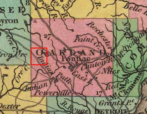
SHIAWASSEE TRAIL - A major trail originating in the vicinity of Detroit and from there heading northwest into the state's interior in what is now Shiawassee County. Durant's 1877 History of Oakland County, Michigan, states that it passed through the middle of Section 35 where it intersected the WALLED LAKE TRAIL coming from the south. From this point the Shiawassee Trial continued northwest across the lower half of the Township, giving passing natives - and later the early settlers - access to what are now called LOWER PETTIBONE LAKE and DUNHAM LAKE. It can be seen on this enlargement of an 1837 map in the lower left corner of the red square depicting Highland Township.
Two remnants of this old trail may yet survive, in the form of REID ROAD, in Highland Township, and Hyde Road, in adjoining Hartland Township. The former begins in the west part of Section 35 (consistent with Durant's description above), then meanders west-northwest, passing the south end of LOWER PETTIBONE LAKE, until it reaches MILFORD ROAD. The latter begins at Tipsico Lake Road, at the south end of Dunham Lake, then heads northwest in the direction of Shiawassee County. If a line is drawn between the west end of Reid Road and the east end of Hyde Road, the result is a diagonal course across the southwest part of Highland Township that closely resembles the route of the Shiawassee Trail as seen on this and other early maps.
WHITE LAKE TRAIL (WHITE LAKE/ROSE CENTER ROAD) - Durant's 1877 History of Oakland County, Michigan, p. 262, notes that White Lake Road (now Rose Center Road) in Rose Township followed an "old Indian trail" that "extended westward toward Shiawassee." Elsewhere, in his account of White Lake Township at p. 187, Durant describes how "The old White Lake road was on the mail trail running from Detroit [Sic: should be Pontiac?] to Grand Rapids, and was the route traveled by persons passing between those two points. It has not been materially changed from its original course, and passes diagonally across the township, regardless of government survey-lines." So too, Franklin Ellis, in his 1880 History of Genesee County, Michigan, p. 203, describes how an early settler arrived in Fenton via the "White Lake Trail" in 1834. Its route is depicted on the 1837 map above, originating near Pontiac and passing just north of WHITE LAKE. It then ran northwest across Section 1 before entering Rose Township. This trail was subsequently surveyed and named WHITE LAKE ROAD. In the early 1900's, however, the diagonal portions in both Highland and Rose townships were rennamed ROSE CENTER ROAD. NOTE: The 1880 History of Livingston County, Michigan, p. 390, refers to this trail as the "Shiawassee or White Lake Road" and suggests it was a branch of the SHIAWASSEE TRAIL. That name, however, is more properly applied to the trail passing through the southeast portion of Highland Township. Others call it the "St. Clair" branch of the Shiawassee Trail, noting that it linked with trails leading to Mt. Clemens on Lake St. Clair.
WALLED LAKE TRAIL - Durant's 1877 History of Oakland County, Michigan, describes the Walled Lake Trail as "doubtless a by-road leading from the Grand river trail," which itself ran west-northwest from Detroit toward the Lansing area (i.e., the approximate route of modern Grand River Road). The Walled Lake Trail is said to have entered Highland Township from the south, intersecting the SHIAWASSEE TRAIL in Section 35. The meandering course of present-day BEAUMONT ROAD - which itself passes north-south through Section 35 - likely incorporate portions of the original trail; especially since an Indian burial ground is located nearby in the Highland State Recreation Area. The Walled Lake Trail likely continued northward to Section 1 to connect with the WHITE LAKE TRAIL that passed north of and gave access to WHITE LAKE.
![]()
Other Natural And Man-Made Features And Landmarks
BI-HU-LI ISLE or ISLAND - A name previously given to what is now HUBBELS ISLAND. While sounding vaguely Hawaiian, it is made up of the first two letters of the last names of Messrs. Edward J. Bissell, Frank Schuyler Hubbell and Mark B. Liddell; prominent businessmen from Milford who built an impressive "cottage" on the island circa 1900. Bissell was a successful attorney, Hubbell established the Milford Electric Company, and Liddell was president of the First State Bank in Milford. The name "Bi-Hu-Li" is applied to this island in the 1908 Standard Atlas of Oakland County, Michigan, George A. Ogle & Co., and is found on several early postcards which show the island and its cottage.
BLINKER, THE - For many years following the construction of M-59 (HIGHLAND ROAD), its intersection with MILFORD ROAD was controlled by a simple "blinker" or beacon which flashed yellow (caution) for through traffic on M-59 and red (stop) for cross traffic on Milford Road. Needless to say this resulted in numerous accidents over the years - many of them serious - before a full three-position stop light was installed in the 1960's. Prior to that time local residents often referred to the intersection informally as "The Blinker," e.g., "There was another wreck at the blinker today..."
BREWERY CROSSING, THE - The name informally given to the point where THE BREWERY ROAD a/k/a THE BENTLER ROAD (now REID ROAD) once crossed the CSX RAILROAD tracks. It derives from the fact Jacob "Jake" Bentler, who owned land along the road, once ran a brewery on his property.
COTTAGE POINT - The name given in the 1908 Standard Atlas of Oakland County, Michigan, George A. Ogle & Co., to the point of land jutting northward into WHITE LAKE in the northeast corner of Section 12. The name is no doubt reflective of the summer cottages built along what is now Woodland Drive in Seven Harbors Subdivision.
DIVINNEY COVE - The name given in the 1908 Standard Atlas of Oakland County, Michigan, George A. Ogle & Co., to the small bay or inlet in the southwest part of WHITE LAKE in the northeast corner of Section 12.
DODGE BROTHERS STATE PARK NO. 10 - In March, 1922, the directors of Dodge Brothers Company agreed to spend up to $350,000 to purchase lands to donate to the State of Michigan for use as public parks in memory of the company's founders, John and Horace Dodge, both of whom had died in 1920. Seven of these park sites were in Oakland County, including Dodge Brothers State Park No. 10 in the northeast quarter of Section 27, Highland Township. In casual conversation the name is usually shortened to simply "Dodge 10." Located southwest of the intersection of East LIVINGSTON ROAD and PETTIBONE LAKE ROAD, the park once featured camping, a toboggan run, playground and other amenities; many built or improved by the Civilian Conservation Corp (CCC) during the Great Depression. It was frequently used as a place to host family reunions, church picnics and other local gatherings. Some 20 years after Dodge Brothers State Park No. 10 was donated, the Michigan Department of Conservation purchased several thousand additional acres of land to the east, including much of Sections 14, 23, 24, 25, 26, 35 and 36 of Highland Township, as well as "Haven Hill," the former Edsel Ford estate in adjoining White Lake Township; thereby establishing the Highland State Recreation Area. While Dodge Brothers State Park No. 10 still maintains a seperate identity, it is now considered part of this much larger park complex
FIRST CREEK, SECOND CREEK, etc. - Names informally given by
long-time Highland residents to the small creeks or streams passing under East LIVINGSTON ROAD east of ELEANOR
STREET, all of which eventually flow into PETTIBONE CREEK
or PICKEREL LAKE. The number corresponds to the
order in which each creek is encountered as one heads east from HIGHLAND STATION. 
GEE'S - Gee's (with the "g" pronounced as in "McGee") grocery and filling station once stood on the northwest corner of what is now M-59 (HIGHLAND ROAD) and DUCK LAKE ROAD in EAST HIGHLAND. Built in 1924, the building was commonly called the "Cement Block Store" since it was built entirely out of ornamental, cast concrete blocks. Until its demolition in the mid-1980's it served as a landmark for Highland residents traveling to or returning from Pontiac.
GROVE POINT SUMMER RESORT - The name given by the 1908 Standard Atlas of Oakland County, Michigan, George A. Ogle & Co., to the summer cottages along the south and west shores of WHITE LAKE in the southeast corner of Section 13. It was owned and managed by James W. Lockwood, and was accordingly sometimes called simply "Lockwood's Resort" or "Lockwood's." The name of Grove Point lives on in that of modern day Grove Street.
HAVEN HILL - A summit or hill (for which the Edsel Ford Estate was named) located in Section 25, more or less precisely on the Township's eastern border, at coordinates 42 deg 38 min 29 sec North, 83 deg 33 min 49 sec West. According to a list of Michigan Highest Named Summits compiled by America's Roof site [no longer on-line], Haven Hill has an elevation of 1134 feet and so ranks as the 57th highest named point in all of Michigan. Notwithstanding the fact Highland Township was so named in the belief it had the highest land in the settled part of Michigan, Waterford Hill in Clarkston Township is now deemed 17 feet higher, with an elevation of 1151 feet.
HUBBEL'S ISLAND - A small island in the southwest portion of WHITE LAKE. Kace Publishing, 1896 Illustrated Atlas of Oakland County, Michigan, shows it as being the property of "C. W. Hubbard." Around 1900 it was known as BI-HU-LI ISLE or ISLAND, but was soon after called "Hubbell's Island" or "Hubbell Island" in honor of Frank Schuyler Hubbell; a prominent Milford businessman who vacationed at the island's cottage. In the mid-20th century the island was purchased by the Presbyterian Church and came to be known as YOUTH ISLAND. In 1999 a proposal was made to change the name yet again to "Hansen Island," but this was rejected by the US Board on Geographic Names (USBGN) in February, 2000. Curiously, the USBGN's "official" designation of this geographic feature is "Hubbels Island," i.e., with only one "l" and no apostrophe.
McCALL'S HILL - A name informally given by long-time Highland residents to the hill or grade on MILFORD ROAD between ROWE ROAD and Watkins Boulevard in Section 34. It is named for the family of Samuel McCall, who owned land on the east side of the road at this point. McCall's Hill still poses difficulties for motorists in the winter, especially those traveling northbound where its grade is steeper.
NEVILLE'S HILL - A name informally given by long-time Highland residents to the hill or grade on East LIVINGSTON ROAD, between the CSX railroad tracks and PETTIBONE CREEK. It was named for Miss Agnes Neville who owned the former James Beaumont house at the top of the hill, on the northeast corner of East LIVINGSTON ROAD and ELEANOR STREET, where she ran a home for boys from St. Vincent de Paul. Local youths often called this grade "Devil's Hill" as a play on and/or corruption of Miss Neville's name.
"OLD MAID'S NIPPLE" - The colorful name given by at least some long-time residents to a hill on the southeast side of PICKEREL LAKE. It was visible from East LIVINGSTON ROAD until obscured by the growth of intervening trees.
"PUTT, THE" - The name given by some long-time residents of WEST HIGHLAND to a series of ponds, marshes and low spots in the southwest quarter of Section 29, beginning north of the East Highland Cemetery and running southeast. When this low area would fill with water and then freeze, it was reportedly possible to skate from the cemetery all the way to LONE TREE ROAD.
"VIADUCT, THE" - The name by which long-time Highland residents commonly refer to the bridge (now bridges) which carries the CSX railroad tracks over M-59 (HIGHLAND ROAD). The term is most often used as a point of reference when giving directions, e.g., "Go west on M-59 until you pass under the viaduct, then make a right on Milford Road..." Prior to its construction, what was then called SPRING MILLS ROAD ran east from HARVEY LAKE ROAD and crossed the tracks at grade before intersecting CENTRE STREET (now MILFORD ROAD). With the construction of M-59 in the late 1930's, however, the decision was made for the highway to pass under the railroad, necessitating extensive excavation and grading both east and west of the tracks. In the process a large spring was uncovered and the resulting water flow was diverted to the east via a pipeline which exits on the present Beach Tree Farm property. Run-off from heavy rains would also sometimes accumulate in the "bowl" under the viaduct and force the roadway's closure due to flooding.
WATERBURY'S SIDING - A name used in the 33rd Annual Report of the Michigan Commissioner of Railroads (1905), p. 48, to refer to the railroad passing siding located between HIGHLAND STATION and WARDLOW ROAD. It was likely named for I. Roy Waterbury, who owned property at the siding's north end at the time. Thus, on December 21, 1905, a "Permit [was] issued to the Michigan State Telephone Company, to string across the tracks of the Pere Marquette Railroad Company, two telephone wires at Waterbury's Siding, one and one-quarter miles north of Highland, Oakland county. Michigan."
YOUTH ISLAND - The name given HUBBEL'S ISLAND following its purchase by the Presbyterian Church and use for outdoor youth activities.
![]()
Introduction
In the late 1800's and early 1900's it became fashionable for local farmers to confer a formal name on their farmstead. This trend was encouraged by the publishers of atlases and plat books who would include such names on their maps for "patrons" who agreed to purchase a copy. Note, however, that such farm names also served a practical purpose, i.e., as a useful address before the days of Rural Free Delivery (RFD).
The following is a list of historic farm names known to have been used prior to 1925. Many of these appear on the map of Highland Township found in the 1908 Standard Atlas of Oakland County, Michigan, published by George A. Ogle & Co., Chicago. Note the number which use the word "Maple," including two different farms called "Maple Hill." In some cases this may have indeed signified the presence of a stand of native sugar maples or related species. In other cases, however, it is known that the maple trees referred to were originally planted by the early settlers themselves as a source of both shade and sugar.
* * * * *
ARK FARM, THE - In the northwest quarter of Section 30, owned by Herbert Bamber in 1908.
BROAD VIEW (BROADVIEW) FARM - In the northwest quarter of Section 8, owned by D. S. Barrett in 1908.
CEDAR LAWN - In the northwest quarter of Section 29, owned by Mrs. Sarah Davison in 1908.
DeGARMO STOCK FARM - In the north half of Section 22, owned by Emily C. DeGarmo in 1908.
HICKORY HURST - In the southeast quarter of Section 4, owned by Adrian O. Mathews in 1908.
HICKORY RIDGE - In the northwest quarter of Section 8, owned by Mrs. E. J. Mills in 1908.
LAKESIDE - In the northwest quarter of Section 14, owned by O. P. Leonard in 1908.
LAKE VIEW - In the northwest quarter of Section 19, owned by John Feeney in 1908.
LAKE VIEW FARM - In the northeast quarter of Section 11 and northwest quarter of Section 12, owned by Alonzo Dean.
LAWN VIEW FARM - In the northwest quarter of Section 30, owned by W. H. Lemmon in 1908.
MAPLE FARM/PINE ROW - See PINE ROW/MAPLE FARM.
MAPLE GROVE - In the southeast quarter of Section 21; shown as the name of the farm owned by Mrs. J. Kelly, but actually the name of the adjoining farm owned by Davis Beach in 1908.
MAPLE HILL STOCK FARM - In the southwest quarter of Section 24, owned by George S. Potts in 1908.
MAPLE HILL STOCK FARM - In the south half of Section 31, owned by W. S. Seaver in 1908.
MAPLE SHADE - In the southwest quarter of Section 17, owned by J. Mack Stark in 1908.
MAPLE ST(REET) FARM - In the southwest quarter of Section 6, owned by C. W. Glines in 1908.
MAPLE VALE - In the southeast quarter of Section 34 and southwest quarter of Section 35, owned by David and L. A. Patterson in 1908.
MEADOW BROOK STOCK FARM - In the northeast quarter of Section 14, owned by J. M Wardlow in 1908.
OAKDALE FARM - In the northeast quarter of Section 6, owned by William E. House in 1908.
OAKHURST STOCK FARM - In the northeast quarter of Section 19 and northwest quarter of Section 20, owned by J. David Ginther in 1908.
PICK STONE FARM - In the southeast quarter of Section 7, owned by H. J. DeGarmo in 1908.
PINE HURST FARM - In the southwest quarter of Section 8, owned by Mrs. William and E. J. Allhouse in 1908.
PINE ROW/MAPLE FARM - Both names appear across the line of two parcels owned by Alonzo Dean in 1908; one in the southwest quarter of Section 12 and the other in the northwest quarter of Section 13.
PLEASANT VIEW FARM - In the southwest quarter of Section 7, owned by Fred A. Skinner in 1908.
RIDGEMERE FARM - In the southwest quarter of Section 5, owned by F. E. Lockwood.
SOUTH MAPLE STREET FARM - In the northwest quarter of Section 29, owned by F. A. Leonard in 1908.
STONE ROWE - In the south half of Section 29, owned by Squire W. Rowe. The name is applied to both the farm and its historic stone house.
SUNNYSIDE - In the southwest quarter of Section 33, owned by A. W. Miller in 1908.
![]()
Introduction
Highland Township's common school system is well covered in both Durant's 1877 History of Oakland County, Michigan, and, more recently, in Marjorie Jackson Bourns, Common School To Consolidation: A History of Huron Valley Schools, 1832-1946, Huron Valley Bicentennial Committee (1976). The latter work is especially valuable for its detailed histories of each individual school, lists of known teachers and their dates of service, etc. In contrast, the scope of the following list is largely confined to consideration of such historic schools as geographical entities, i.e., giving their locations and names.
* * * * *
A-RAB (Fractional District No. 3) - This frame school was built prior to 1850 on the west side of MILFORD ROAD, just south of Watkins Boulevard, in Section 34. It replaced a log school some distance away which originally served this district. It stood until 1874 when sold and moved to another location to make way for the replacement EXCELSIOR SCHOOL building. The origin of its unusual name (pronounced with the accent on the "A") is unclear. One wonders, however, if it might bear any relationship to "street arab;" a 19th century term for a vagabond or delinquent child.
BEAUMONT (Fractional District No. 7) - This two-room frame school, built in 1938, still stands at the southeast corner of DUCK LAKE ROAD and Jackson Boulevard in Section 12. It was named for John F. and Harry S. Beaumont, who donated the land on which the school stands. The building continued to be used as school until the 1940's. Since then it has seen use by church groups, a day care center and fraternal organizations.
CLYDE (District No. 3) - This frame structure still stands at its original location on the northeast corner at the intersection of MILFORD ROAD, HARVEY LAKE ROAD and WHITE LAKE ROAD in Section 2. It is currently (2009) being used as a pre-school/day care center.
EXCELSIOR (Fractional District No. 3) - This frame school stood on the west side of MILFORD ROAD, just south of Watkins Boulevard, in Section 34. It was built in 1874, replacing the so-called "A-RAB" school building which previously occupied the site. It was sold in 1936 and thereafter used for many years as a home before being demolished in the 1970's to make way for what is now (as of 2009) Gil-Roy's Hardware.
GRUBB (Fractional District No. 4) - This frame school stood occupied a one acre site at the northwest corner of GRUBB ROAD (now East LIVINGSTON ROAD) and DUCK LAKE ROAD in Section 24. Its was presumably named for GRUBB ROAD. Edsel Ford purchased the property in 1936 to keep picnickers away from his Highland estate (now part of Highland Recreation Area). The building was thereafter moved north to the northeast corner of M-59 and LaSalle Boulevard where it still stands, albeit greatly modified, as a commercial office building.
HICKORY RIDGE (Fractional District No. 2) - The original school stood on the west side of North HICKORY RIDGE ROAD, just south of CLYDE ROAD, on land given by Edmund Lockwood in Section 7. Built circa 1850-60, it measured 30 x 40 feet and was constructed of local stone in a simple Greek Revival style. On November 7, 1930, a fire of unknown origin destroyed the original stone building and a replacement frame structure was hastily erected in time for use by January 1, 1931. It closed several years later when bus service became available to the new brick school at HIGHLAND STATION (now part of Highland Middle School). The replacement frame school was then moved to Highland Station, where it was attached to the south side of the Highland Methodist Church for use as a social hall. Although now greatly modified - especially after renovation for use by the Highland Township Library - this replacement school still exists as part of the former church complex.
HIGHLAND (District No. 4) - Also sometimes called the UNION SCHOOL, this frame school stood at the northeast corner of CENTRE STREET (now MILFORD ROAD) and SPRING MILLS ROAD (now M-59) in Section 22, just south of the present-day McDonald's restaurant. Originally built c. 1860, it was enlarged c. 1880 by the addition of a second room. Construction of M-59 in the 1930's took so much of the schoolyard that the State Highway Department agreed to contribute $5,250.00 toward the construction of a new, brick building on North JOHN STREET (now part of Highland Middle School).
LYMAN (District No. 6) - This school stood on the C. Lyman farm on WARDLOW ROAD, just west of DUCK LAKE ROAD. The first frame building was erected c. 1840, but was soon replaced by a second, white frame building built c. 1858. Eventually the number of students attending this school grew so small that it was closed in 1910, with the remaining pupils divided between the GRUBB (Fractional District No. 4) and CLYDE (District No. 3) schools. The school house was sold to Lewis Treat, who used the lumber to build a home on Lone Tree Road.
TENNY (District No. 1) - See WEST HIGHLAND (District No. 1)
UNION (District No. 4) - See HIGHLAND (District No. 4).
WEST HIGHLAND (District No. 1) - In 1834 a two-room log cabin was built on the farm of Jesse Tenny on LONE TREE ROAD, west of HICKORY RIDGE ROAD. One room was paid for by the school district and it was here the first Township meeting ever held in Highland was called to order on April 6, 1835. On Sundays a movable partition was removed and both rooms of the cabin were used by the West Highland Baptist Church until its own church building was completed in 1852. In 1860 the log school was abandoned and a frame building was constructed on land given by the Tenny family on the west side of South Hickory Ridge Road, across from the West Highland Cemetery. This burned on January 10, 1928, and was replaced by second frame building. After consolidation of Highland's schools in the 1930's this second building was moved to the corner of RUGGLES STREET and North JOHN STREET, across from what is now Highland Middle School, where it was used for several years as the "Kindergarten Cottage" before becoming home to the Huron Valley Schools Credit Union. While substantially remodeled in the 1990's, portions of this second frame school building still remain.
TO BE CONTINUED... ADDITIONS AND CORRECTIONS ARE INVITED!